Flooding forces closures and evacuations in Kruger National Park
Persistent heavy rainfall across Limpopo and Mpumalanga has caused severe flooding in and around the Kruger National Park, prompting SANParks to suspend day visitor access, evacuate rest camps, close key gates, and restrict internal routes to protect guests, staff, and surrounding communities.
Click here to view the videos SANParks' FB page
Persistent and heavy rainfall across Limpopo and Mpumalanga Provinces has placed significant pressure on the Kruger National Park and surrounding communities, prompting precautionary closures, evacuations, and access restrictions as safety concerns escalate.
As of Thursday, January 15, South African National Parks has suspended access for all day visitors to the Kruger National Park until conditions improve. The decision was taken as a preventative safety measure, with SANParks confirming that the ongoing rainfall has placed considerable strain on operational and emergency response resources.
The organisation has indicated that available capacity must be prioritised for real emergencies and for ensuring the safety of guests, staff, and neighbouring communities, rather than for avoidable incidents linked to non-essential travel within the park.
SANParks has stated that the restriction on day visitors will be reviewed continuously as weather patterns and road conditions change. The organisation has apologised for the inconvenience and has thanked the public for their cooperation during this period, emphasising that visitor and staff safety remains its highest priority.
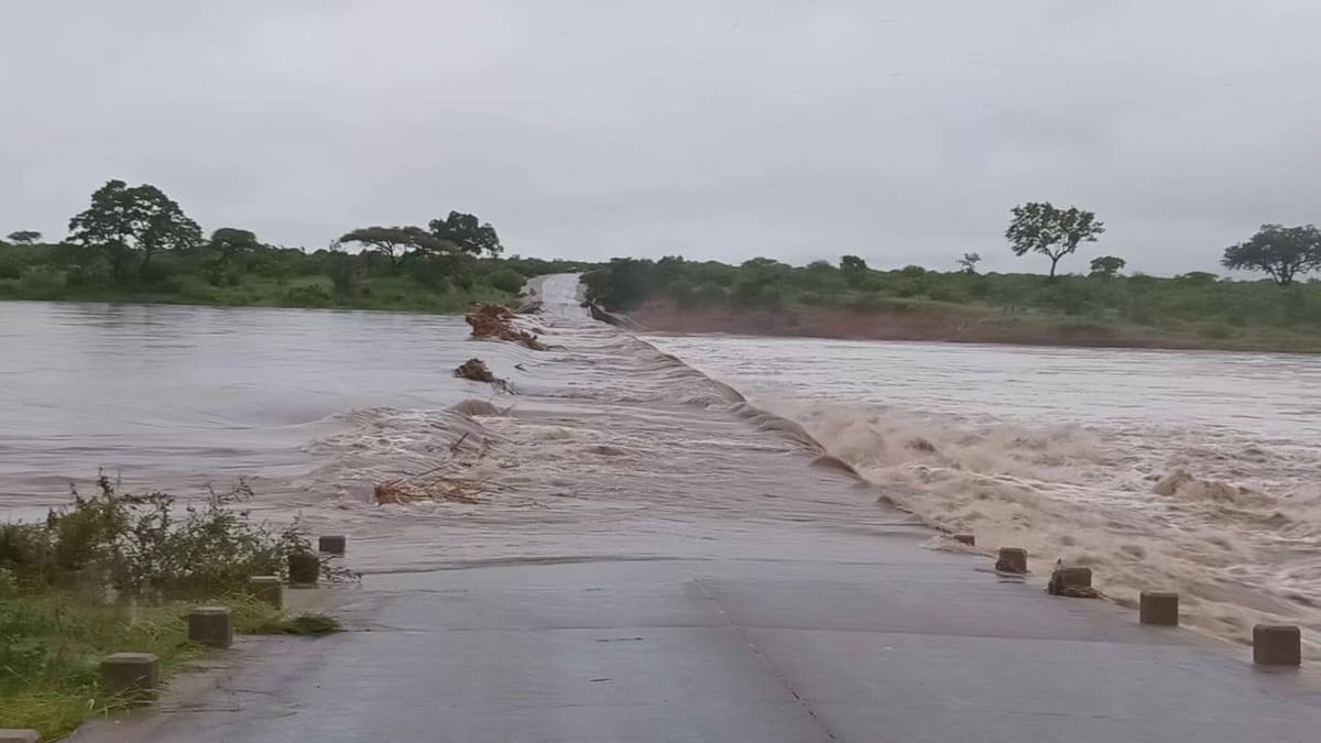
Conditions within the park have deteriorated rapidly in several areas. Letaba Rest Camp and several other rest camps have been fully evacuated, with both guests and staff moved to safety after floodwaters from the rivers breached the riverbanks and entered the camps.
Persisting rainfall has affected several access routes and gates across the park, requiring strict adherence to designated entry points to avoid further disruption. Guests accessing Skukuza Rest Camp are advised to use Paul Kruger Gate. Phabeni Gate remains open at present, although SANParks has warned that it may close at short notice should river levels rise further.
Several internal routes within the park are also closed due to flooding. There is no access from Skukuza to Lower Sabie, Crocodile Bridge, Tshokwane, or Satara, as the Sabie Low Water Bridge and associated detours are flooded. The H10 road between Lower Sabie and Tshokwane is closed, while access to Pretoriuskop Rest Camp is limited to Numbi Gate or Phabeni Gate.
The closures coincide with an extreme weather alert issued by the South African Weather Service. On 15 January 2026, SAWS issued a Red Level 10 Warning for disruptive rainfall over parts of Limpopo and Mpumalanga, citing an ongoing high risk of widespread flooding. The warning highlights the danger to life posed by fast-flowing rivers and streams, flooding of roads and bridges, damage to infrastructure and settlements, and the displacement of communities.
Forecast guidance indicates that a further 100 to 200 millimetres of rainfall is possible over the next 24 to 48 hours in several municipalities, including Maruleng, Ba Phalaborwa, Nkomazi, the City of Mbombela, Bushbuckridge, Greater Giyani, Greater Tzaneen, Greater Letaba, and Collins Chabane. These additional rainfall amounts are expected to fall on already saturated catchments, significantly increasing runoff and flooding potential.
Observed rainfall data for the period between 11 and 13 January 2026 confirms widespread accumulations exceeding 50 millimetres, with localised totals of between 100 and 200 millimetres across eastern Limpopo and eastern Mpumalanga. Repeated rainfall over the same regions has contributed to rising river levels and severe flooding conditions.
SAWS has advised residents and visitors in affected areas to avoid crossing flooded roads, bridges, and rivers, to move to higher ground where flooding occurs, and to follow instructions issued by disaster management authorities. The weather service has stressed the importance of monitoring official forecasts and warnings, while cautioning against the spread of unverified information.
Weather conditions are expected to begin stabilising from around 19 January 2026, when only a low chance of showers is forecast. More stable weather is anticipated from 20 January onwards, which should allow river levels to gradually recede. Until then, SANParks and emergency services remain on high alert as flooding continues to affect one of South Africa’s most important conservation areas and its surrounding communities.

Comments ()